


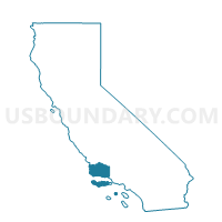
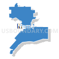
Voting District 10396, Santa Barbara County, California
About
Outline

Summary
| Unique Area Identifier | 543221 |
| Name | Voting District 10396 |
| County | Santa Barbara County |
| State | California |
| Area (square miles) | 4.80 |
| Land Area (square miles) | 4.79 |
| Water Area (square miles) | 0.01 |
| % of Land Area | 99.69 |
| % of Water Area | 0.31 |
| Latitude of the Internal Point | 34.43653030 |
| Longtitude of the Internal Point | -119.68207520 |
Maps


Graphs
Select a template below for downloading or customizing gragh for Voting District 10396, Santa Barbara County, California


Neighbors
Neighoring Voting District (by Name) Neighboring Voting District on the Map
- Voting District 10386, Santa Barbara County, CA
- Voting District 10391, Santa Barbara County, CA
- Voting District 10392, Santa Barbara County, CA
- Voting District 10406, Santa Barbara County, CA
- Voting District 10516, Santa Barbara County, CA
- Voting District 10521, Santa Barbara County, CA
- Voting District 10526, Santa Barbara County, CA
- Voting District 10576, Santa Barbara County, CA
- Voting District 20381, Santa Barbara County, CA
- Voting District 20412, Santa Barbara County, CA
Top 10 Neighboring County Subdivision (by Population) Neighboring County Subdivision on the Map
Top 10 Neighboring Place (by Population) Neighboring Place on the Map
Top 10 Neighboring Elementary School District (by Population) Neighboring Elementary School District on the Map
- Santa Barbara Elementary School District, CA (83,498)
- Montecito Union Elementary School District, CA (6,182)
- Cold Spring Elementary School District, CA (2,952)
Top 10 Neighboring Secondary School District (by Population) Neighboring Secondary School District on the Map
Top 10 Neighboring State Legislative District Lower Chamber (by Population) Neighboring State Legislative District Lower Chamber on the Map
Top 10 Neighboring State Legislative District Upper Chamber (by Population) Neighboring State Legislative District Upper Chamber on the Map
Top 10 Neighboring 111th Congressional District (by Population) Neighboring 111th Congressional District on the Map
Top 10 Neighboring Census Tract (by Population) Neighboring Census Tract on the Map
- Census Tract 8.04, Santa Barbara County, CA (7,189)
- Census Tract 7, Santa Barbara County, CA (6,408)
- Census Tract 10, Santa Barbara County, CA (6,270)
- Census Tract 6, Santa Barbara County, CA (4,629)
- Census Tract 12.06, Santa Barbara County, CA (4,480)
- Census Tract 12.08, Santa Barbara County, CA (4,096)
- Census Tract 8.01, Santa Barbara County, CA (4,059)
- Census Tract 14.02, Santa Barbara County, CA (3,392)
- Census Tract 9, Santa Barbara County, CA (3,266)
- Census Tract 5.01, Santa Barbara County, CA (3,263)